La rocca della Lanterna

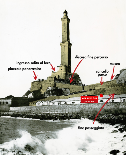
La Lanterna in una foto di Alfred Noack nel 1885. Il mare lambiva ancora il promotorio di San Benigno // The Lanterna in a photo by Alfred Noack in 1885, when the sea still lapped the promontory of San Benigno
La punta del promontorio
chiudeva in un abbraccio il golfo naturale di Genova
Ora siete sulla Rocca della Lanterna. É tutto ciò che resta del promontorio di Capo di Faro, che si spingeva un tempo in mare aperto.
Ogni viaggiatore che voleva entrare a Genova arrivando da ponente doveva attraversare il varco nelle mura cittadine ai piedi del faro (la Porta Nuova realizzata sotto il governo sabaudo nel 1831). Dopodichè poteva proseguire in quota su parte delle mura fino al piazzale oggi detto ‘di San Benigno’ (che altro non è che il parcheggio a metà passeggiata) dove si ergeva dal 1630 la Porta Vecchia e poi scendere verso la città facendo lo stesso percorso che si fa oggi per tornare al Terminal Traghetti.
Un’altra possibilità, passata la Porta Nuova, era quella di scendere lungo il percorso a tornanti dove vi trovate ora e raggiungere il bastione sulle rocce che concludeva l’estensione delle fortificazioni verso il mare o scendere più giù ancora fino al molo nuovo, che era stato voluto nel 1638 dai Padri del Comune per proteggere il grande bacino del porto dalle tempeste.
Nonostante i grandi cambiamenti nel contesto urbano e paesaggistico, la salita al faro arrivando dal porto è tutt’ora esattamente quella del percorso storico (inclusa un’antica galleria voltata che si percorre arrivando in macchina) e faceva parte delle ‘mura nuove’ costruite a partire dal 1630.
The Lighthouse Rock
The tip of the promontory embraced
the natural gulf of Genoa
You are now on the rock that houses the lighthouse, aka ‘Lanterna’. This is all that remains of the promontory called ‘Capo di Faro’, which once stretched out into the open sea.
Travellers wishing to enter Genoa from the west had to pass through the gate in the city walls at the foot of the lighthouse (‘Porta Nuova’ or New Gate built under the Savoy government in 1831). They then continued walking along the city walls as far as the square where the Old Lighthouse Gate was built in 1630 (today this gate is called ‘San Benigno’, and is in the parking area in the middle of the walkway), and then descended towards the city, following the same route that today leads back to the Ferry Terminal.
Another possibility after crossing ‘Porta Nuova’, was to follow the winding path you are on now; from here, you could reach the bastion on the rocks that marked the end of the fortified walls stretching out towards the sea or go down further to ‘Molo Nuovo’ (New Pier), built in 1638 by the Fathers of the Community to protect the large historic harbour from storms.
Despite the great changes in the urban context and landscape, the walkway to the lighthouse coming from the port is still exactly the same as the historical route (including an old, vaulted tunnel you can drive through) and was part of the new walls built by the Republic of Genoa starting in 1630.
